The first "natural" bushland on the north bank of the Brisbane River is under attack ... by Brisbane City Council ...!
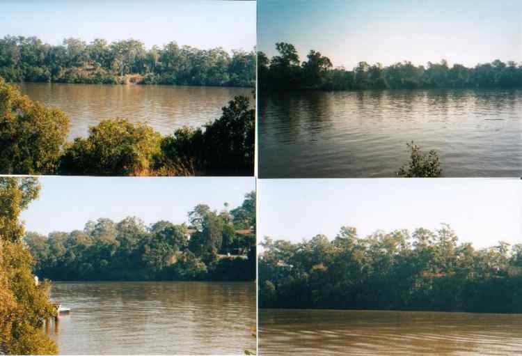
As you travel upriver from the mouth, there is no "natural" bushland until upstream of the University of Queensland (UQ) where suddenly, the "bush" is dense enough that houses and the road can't be seen (see the attached photos from Yeronga).
One might expect this to be valued by Council as part of its "environmental" and "ecological" responsibilities. Certainly, while some sections have weed infestations, a very keen band of locals have carried out some extraordinary "regeneration" projects under the guidance and with funding/assistance of Habitat Brisbane etc.
It is worth a visit although it is a bit dry at present ... as it should be for this type of natural woodland/mangrove river border at this time of year in Brisbane.
But now, despite local resident's concerns and objections to local Brisbane City Councillor Judy Magub, this wonderful bit of bush is under threat ... to be destroyed for a bikeway. (For a comparison, have a look at how many of the wonderful eucalypts along Coronation Drive have survived the widening and bikeway.)
Residents have pointed out that the adjoining roads (The Esplanade and Hillside Terrace) have long been identified by BCC as a "bike route" although the road surface is currently in appalling condition and illegal parking normal. It is also a fast developing rat-run to UQ which means that residents amenity could be improved by a road project aimed at slow traffic speeds and designed for cycling. Council has apparently refused that option in favour of yet another bikepath in the bush.
Bits and pieces of concrete footpath in front of some of the houses have also been installed by Council or others but none is connected and most is substandard and in many cases dangerous. Why was this allowed by Council or alternatively, why was it built this way by Council? It should all be re-built to provide access on foot, to and from the houses.
Thus it seems that despite all the environmental rhetoric and the green levy and "bushland care" and "Habitat Brisbane", the valuable remnant links can simply be turned into roads or building sites by Council, whether or not this is the intention of the myriad of "environmental protection" plans, strategies and regulations.
Here where whip-birds can often be heard, we have the first section of a continuous river margin upstream. Is it Council's "ecological" policy to erode these margins irrespective of their "ecological" value?
Feel free to have a look at this and the adjoining St Lucia Golf Course, where along the Hillside Terrace margin, Council intends to remove or threaten the survival of most of the remaining bush ... rather than threaten the increasing numbers of motorists driving to and from UQ.
It is time that residents across Brisbane realised that Council is using a combination of "divide and conquer consultation" and "death by 1000 lashes environmental vandalism" whilst pursuing a programme of expensive PR and in some cases, funding of some "symbolic" projects, many of which are likely to end up as roads or drains due to policies that place "environment" and "local community amenity" last ... and development and increased volumes of traffic first.
The way to judge Council's performance is to look at bushland and creeks such as in this area to see how they are being managed and what plans are available for their protection and regeneration as significant remnants and links for wildlife as well as reasonable examples of the original conditions at the river edge margins.
In the case of Sandy Creek, the St Lucia Golf Course and the bush margins of the river, it appears there are none ...!
Michael Yeates
for Friends of Sandy Creek
michaelm@myoffice.net.au
This page is maintained by
The Rivermouth Action Group Inc
as a community service.
E-mail: activist@rag.org.au