Hi Deb
Please find attached .jpg files.
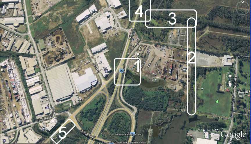
The base map used for you proposed development was
certainly taken during the dry season see my attachment.
The .jpg map is from Google Earth. Please
note the direction of North on this map.
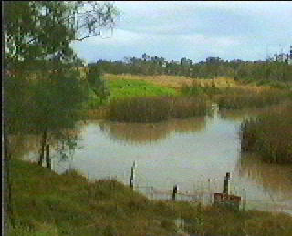
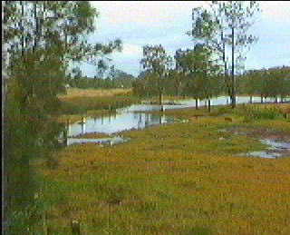
Area 1
Is a wetland area. see attached photos taken
several years ago. There was originally a pipe under the original Lytton
Road at this point which was replaced when the existing Lytton Road was built
but could not be found when stage one of the port road was built. Most
probably a metre below ground level as the old Lytton road sunk into the mud
below about a metre and a half since it was built in the mid 1960's due to the
heavy traffic using it.
There was originally a drainage channel on the west
side of Lytton Road which drained back towards Anton Street which has been
filled in which allowed this area to drain towards the Bulimba Creek via Anton
Street.
When Lytton Road was upgraded for the oil refinery
development the creek corridors were changes and the new Lytton road became
a large dam from Bulimba Creek at Hemmant to the Ampol (now Caltex) refinery
which resulted in flooding of many upstream properties. Higher that had
ever been experienced before this road.
Lytton Road I remember as a young child had flood
gates across all the creeks flowing into Bulimba Creek and the Brisbane River in
the area. I can remember at least 4 flood gates across the creeks.
One near the Hemmant Hotel. Another on Anton Street near where metal corp are
now. One at area 4 on my map and another north near Prichard Road and
Lytton Road.
Area 2
This is a water corridor drainage channel which has
been changed and filled over the past 50 years. When the State government
resumed all the land north of Sandy Camp Road some 40 years ago fill was placed
across this area north and west of Sandy Camp Road making tracks suitable for
driving vehicles allowing for even more fill to be placed in this area.
The drainage channel in Area 2 was dramatically restricted and no government
department wants to know anything about it. Of course the department
responsible (actually irresponsible) for this dilemma no longer exists due to
changes in ministerial responsibilities over the decades since.
The land to the east of Area 2 was also once a
large wetlands but has been filled by the Iona College for sports
fields.
The original drainage channel was dug by hand
during the 1930's depression to allow excess water to drain from the
fresh water wetland after heavy rain and was observed by my father during his
early teenage years.
Area 3
Has been allowed to silt up due to the past actions
of the Harbour and Marine Department who were then responsible of the further
reclamation of Cooney's Flats (there is a new name now). Fine silt from
this area was allowed to run into this water corridor on all tides from the
reclamation works. This deposited both up stream and down stream of
Lytton Road making this creek very shallow. Also other industrial
activities have tended to reduce the flood capacity and drainage of this land
east of Lytton Road. The Filling for the Lytton Industrial estate the port
rail line, filling for sports fields, and housing development in the
catchment. No government department wants to know about this
problem.
I have read the BCC flood studies for Bulimba
Creek, Hemmant Creek and Lindum Creek and none of these studies acknowledge any
problems north of the rail line (Brisbane to Cleveland) else Hemmant to
Lindum. Flood waters from Bulimba Creek flow back towards Lindum creek
then pass under the rail line and when they cannot flow via Lindum Creek under
Lytton Road and Gosport Road (near Anton Street) they cross Lindum Road at 102
and fill the wetlands north of Lindum Road but have highly restricted out flows
from this catchment due to the road developments in the past.
The EIS on the Port Road by Maunsell notes that the
culverts under the rail line between Lindum and Hemmant Rail line are under
sized. Yet Maunsell were the Consultants for the Port Rail as
well.
Also in the past (40 years) someone poured a
concrete base on the creek corridor to allow access across the creek.
Maybe some locals wanting to drive their old cars or some dirt bike riders we
have no idea but this also has caused a restriction of the out flow of flood
waters from this catchment.
Area 4
The culverts under Lytton Road are not under any
maintenance plan as several years ago I video them. Of the four pipes only
one was not full of mud etc. And that one was only partly open. It
took a couple of years to have it dug out. When this action was taking
place the contractors discovered that a gas or oil pipeline had been laid on the
East side of the culvert half way the height of the culvert blocking water
flow. The pipe was eventually re-laid below the level of the bottom
of the culvert pipes. Due to the AHD levels of the wetlands to the east of
the Port Road the flood waters can most probably only drain successfully on low
tides. Therefore it is important that there is a unrestricted flow on low
tides as to reduce the flood levels as soon as possible.
The wetlands to the east are and always have been
fresh water. The salt water was always held back by flood gates which have
as I said before removed decades ago allowing mangroves to colonise to the east
and further restrict the water corridor.
Area 5
Is a remnant of the first stage of the Port Road
and is a prime example of We Don't Care About the Environment and
inspectors/engineers who would not know what they were looking at. This
entire area is Acid Sulphate Soils (ASS). This area was never treated for
ASS and has been leaching acid since stage one of the Port Road was built.
I hope that some action is taken and is not duplicated in this next
stage.
I would appreciate a meeting some time next week
with rep from Port Road and an engineer and hydrologist who has already look at
these problems I have mentioned above and who can shed some light on how these
issues can be resolved.
As a foot note I hope that sediment fences are
required and that some one independent contractor will be responsible for their
correct installation as per the Queensland's Institute of Engineers Hand book
and daily maintenance for the full term of the development takes place. I
have seen pathetic sediment fencing. Examples attached are of
concern.
Barry Wilson
Chairperson
The Rivermouth Action Group Inc
P.O. Box 268
Morningside Qld 4170
4 April 2011
----- Original Message -----
Sent: Monday, April 04, 2011 2:24
PM
Subject: Port Connect maps
Hi Barry,
Thank you for your call this morning.
Please find attached two maps of the Port Connect alignment
one outlining specific features of our project and the other just shows the
alignment.
As discussed, please mark up your areas of interest and the
specific queries and concerns you have regarding these areas. I will need you
to be as specific as possible in order to gain advice from our team so that I
can provide advice back to you.
Depending on what information is available and where were
up to in the final design we can discuss next Monday if a meeting on site is
necessary.
Kind regards,
Deb
Daly |
Communication Officer
BMD
Seymour Whyte Joint Venture |
Port
of Brisbane Motorway Upgrade Project
Level
1, 17 Henry Street Spring Hill Qld 4000
PO Box 197 Wynnum Qld 4178 | Phone:
07 3316 3797 | Mobile: 0418 507 847
Email:
deb.daly@pobm.com.au
No virus found in this message.
Checked by AVG - www.avg.com
Version: 10.0.1209 / Virus Database: 1500/3548 - Release Date: 04/03/11
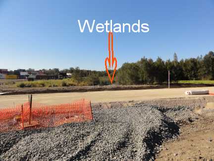
Photos below of wetland are/were
in the way of the port road second stage.
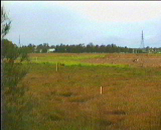
What I saw in July 2011 of the same
area above.
Below are prior examples of poor
sediment control I have photographed elsewhere on road construction and subdivision.
ADDED NOTATION:
The photos below
(some from video) are of previous work site of Seymour White and from a BMD
work site.
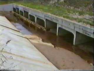
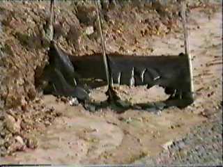
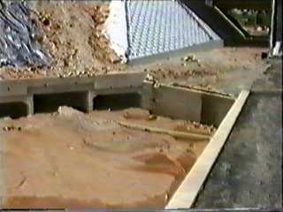
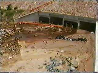
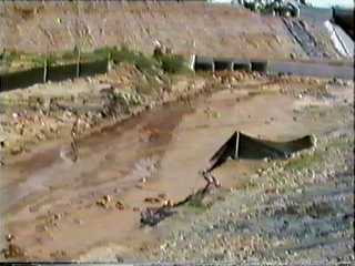 These 5 images are from video taken during the construction of the Capalaba
bypass at the Old Cleveland Road end.
These 5 images are from video taken during the construction of the Capalaba
bypass at the Old Cleveland Road end.
Queensland Environment Department
used some of my video of the above images in their TV campaign about the need
for sediment fencing and therefore Healthy Waterways.
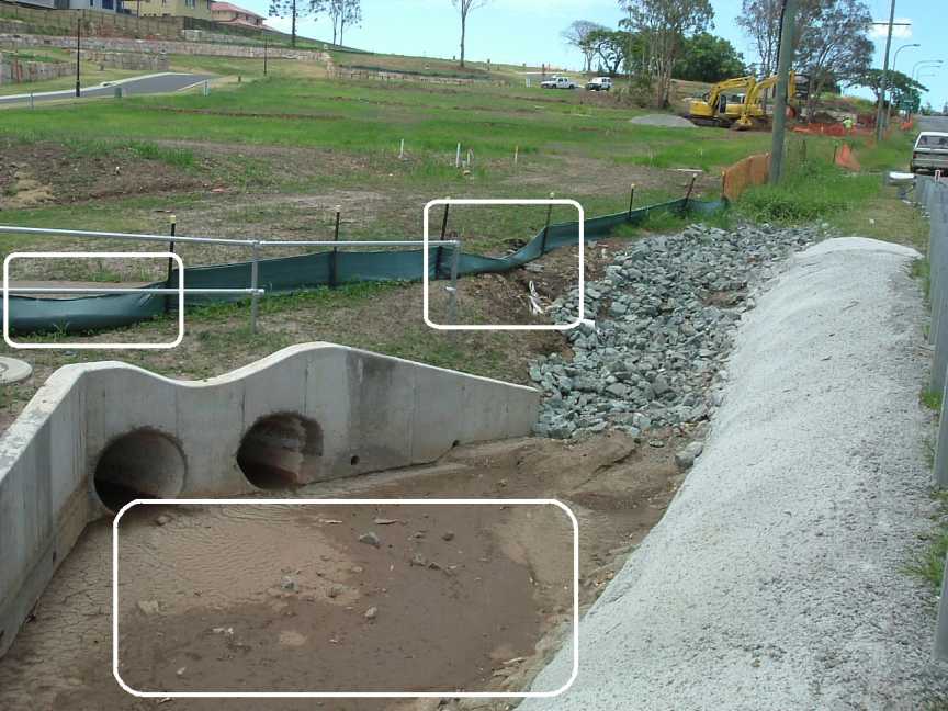
The photo above taken from Green
Camp Road Wakerley.