Submission to Department of Environment and Resource Management.
This is my 2011 submission asking DERM to take some action to inspect and approve the removal of the mangroves to allow maintenance dredging of this entire darinage channel at Lytton.
To inspect their own nearby property and undertake drainage maintenance.
----- Original Message -----
From: Butcher Paul
To: activist@rag.org.au
Cc: Bowden Deb
Sent: Friday, August 26, 2011 11:08 AM
Subject: Lindum drainage issues
Hi Barry,As discussed on the phone this morning, my unit manager is seeking clarification from you as to what outcome you are hoping DERM would achieve with regard to the issues you raise on your website and in our discussion of 29 July. Could you please provide the following:
· A brief summary of what you perceive the issue to be;
· What you would like to see occur;
· What role you believe DERM has in this issue;
· Real property details of any DERM-owned land;
· Real property details and ownership details of other land in the subject area;
· Names and contact details of people you have discussed this with recently, i.e BCC, Port Connect, Port of Brisbane, any other government department representative.
With this information I can better understand what DERM can do to investigate and potentially resolve issues on environmental significance.Regards
Paul Butcher
Principal Environmental Officer - Brisbane City South
Environmental Services - South East Region
Department of Environment and Resource Management
Ph:(07) 3238 3819 Fax: (07) 3406 2578Level 4 Landcentre, Cnr Main and Vulture Streets, Woolloongabba Q 4102
GPO Box 2771 BRISBANE QLD 4001
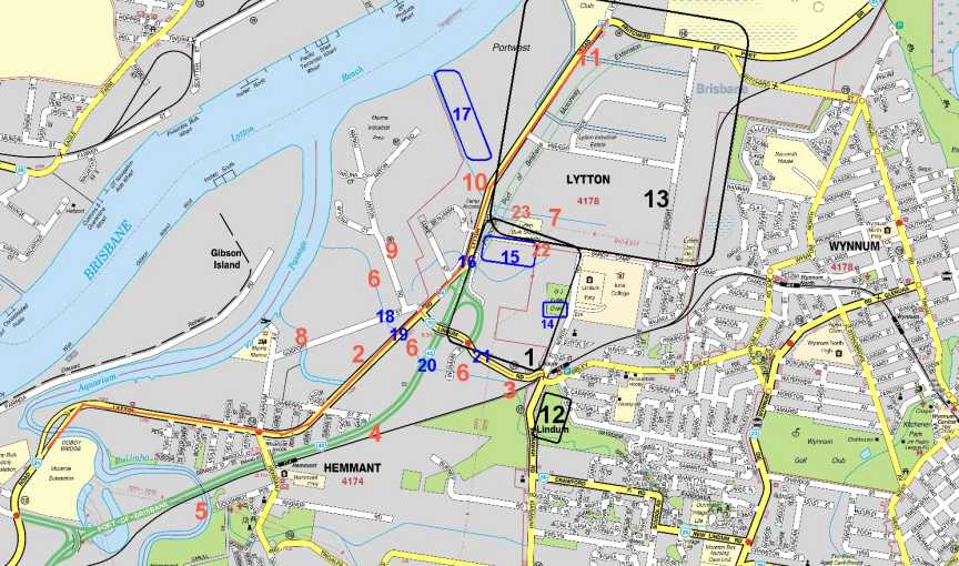
Key Map
To Paul Butcher
Department Environment and Resource ManagementHi Paul
Thank you for your email and interest.
Also thank you for taking the time to read my web site on the issue. http://www.rag.org.au/lytton (unlisted web site at present)
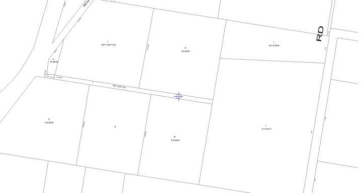
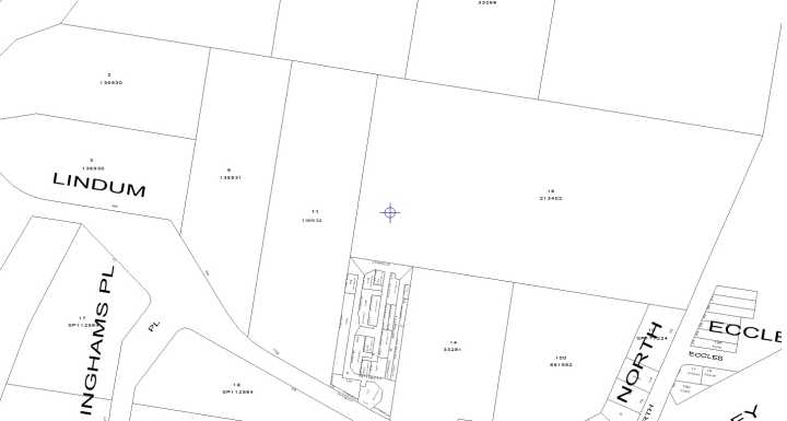
I have attached a map and refer to numbered areas above.
Point 1 response.
The issue is that over the past 40+ years the Queensland Government actions have been solely responsible for the increased flooding, both increased levels and duration within the area bounded by Lytton, Lindum, and North Roads Lytton/ Wynnum West. (Area 1 marked with a black rectangle.)
This is not the same reason as suggested in the response by the past Minister for Natural Resources, Welford on the 10 March 1999 to Paul Lucas which is on my web site which suggests the problem was urban development. Just how much research did the Minister's staff and correspondence unit actually do as they certainly did not know what they were talking about. This is exactly why I have developed my web site containing the evidence and proof.
This increased flooding started with the upgrading and realignment of Lytton Road to the oil refinery at Lytton. (Red line numbered 2 on map) Lytton Road was built some 2 meters higher that the original Lytton Road which then formed a retention dam across the entire catchment of Bulimba Creek, Hemmant Creek and Lindum Creek. Limited drainage was installed under this upgrade and not maintained very well since.
The building of the Port Dual Gauge Rail Line resulted in under sized culverts between Lindum and Hemmant railway stations. (Refer to Maunsell EIS on Port Road) (numbered 3 & 4 on map)
The port road's first stage and the port dual gauge rail line also ended up increasing the upstream flooding levels in Bulimba Creek. (south of the rail line). (Numbered 5 on Map) (TMR own admissions.)
After the Lytton Road upgrade, 2 new wider drainage channels (Lindum Creek (numbered 6 )and Port West drainage channel east of Lytton Road (numbered 7 ) were dug and alignments changed and existing flood gates (numbered 8, 9, 10 & 11) which stopped tidal waters from entering fresh wetland areas were removed at some point in time.
As a result acid sulphate soils were disturbed and tidal waters were allowed to flood into several fresh water wetlands. One such example is the area east of Kianawah Road south of Sibley Road. (area numbered 12 on Map) There were never any mangroves along what is now drainage channel numbered 7 but now is a dense inland mangrove forest.
Then when the Queensland Government resumed the land north of Sandy Camp Road for Port Industries and Industrial Estate, a large fresh water wetland was drained in filled thus massively reducing the flood capacity of all the area east of Lytton Road. (area approx that of black rectangles numbered 13 and 1)
Iona College also filled in a large section of a melaleuca Wetland to build their sports field on the western side of North Road. (Blue rectangle and numbered blue 14 on map)
A container park has been developed on the east side of Lytton Road just north of the Lytton Road intersection with Lindum Road which resulted in even more fill being placed with this catchment reducing capacity of flood waters. (blue rectangle and numbered 15 on map)
When Lytton Road was upgraded a drainage line which had always existed just north of Lindum Road which allowed drainage from (area 1) across to Anton Road was not maintained thus further reducing the ability to this area between Lytton, Lindum and North Roads to drain. This creek/drain/water corridor is still able to be seen on the UBD maps of the area and quite visible on older photographic maps on my web site. The new Port Road extension and upgrade presently be undertaken at present will further reducing the flood capacity of this area in question. (numbered 16 on Map)
Because of the relatively low height of the Old Lytton Road flood waters could flow over it very easily over a long length of it at a minimum depth. Once the new Lytton road was built flood waters could only escape through the new culverts and there are only a few of them. Also the culverts, which existed when I was living at Lindum up to 1969, under the rail line if you could call them that were actually wooden bridges which did not restrict water flows.
The development of Port West has resulted in a reduced drainage capacity as it filled then bunded what was the riparian zone of the drainage channel. (area number 17.) This area was once called Cooney's Flats has been subject to dredge spoil filling over the past near 80 years. The photo map from 1958 on the web site depicts this area of mangroves quite well.
These actions have resulted in the removal mangroves as the dredging spoil was pumped in the late 1950's or early 1960's. The Government photographic maps on my web site prove this.
What happened was that when the dredge spoil was pumped in (to Port West) the excess salt water was allowed to drain into the drainage channel in the south east corner of the area near Lytton Road. (At about number 10 on map) This resulted in the fine silt being deposited in the drainage channel and subsequently result in the blockage to tidal flow to Lytton Road. This blockage is also shown in photographs on my web site.
The drainage channel which is near the Hemmant Hotel on Gosport Street (numbered 8 on map) has never been maintained in the 64 years I am aware of and presently the banks including trees are collapsing into the creek. I took photos a few weeks ago. Flood Gates (numbered 8) existed when I was younger on the Bulimba Creek side of Gosport Street which was at that time called Lytton Road.
When it comes to the drainage channel referred to as Lindum Creek it was realigned and the old alignment along the east side of Anton Road also had a Flood Gate near where Metal Corp are now. (numbered 9)
The existing culvert under Gosport Street near Anton Road (numbered 18 on map ) I believe are undersized compared with Culverts further downstream under Lytton Road (numbered 19) and the Port Road (numbered 20 on map). This results in restricted flows and during flooding times the flood water in an attempt to reach the Brisbane River flows across Lindum Road instead of through the Gosport Street channel. (numbered 21 on map) Once flood waters are in catchment area (numbered 1 on map) the waters are restricted by a pair of undersized pipes (numbered 22 on map) which is the only way this flood water can exit this wetlands. This restricted drainage is due to Government reclamation works in the Lytton Area. (area numbered 13 on map) Presently these two drainage pipes are in need of maintenance and should be redesigned by lowering and increasing the number of culverts and have a lower road surface above them.
Some 40 years ago after the new drainage channel (numbered 7 on map) was made from Lytton Road to the east towards Wynnum North parallel to Sandy Camp Road persons unknown built a crossing of rocks and concrete across this drainage channel resulting in reducing the level to which the flood waters could drain on low tides. (Numbered 23 on map)
I aware that the wetland (numbered 1) will and could never completely drain because if connected to the river this wetland would be subjected salt water tidal inflows 20% of the time and this is not the solution.
The Brisbane City Council engineer (Local Area Co-ordinator) I spoke to last week suggested that he would like to see flood gates reinstated inland of the about to be built Port Connect road.
Phone calls, letters, personal contacts with Local and State Government members has not resulted in any remedial works to take place since the Lytton Road over more that 30 years. Refer to correspondence on the web site.
Port Connect has according to their correspondence via email to me says that they have advised the Port of Brisbane that the drainage channel near Port West needs to be cleaned out. Area between Number 10 and the Brisbane River)
I spoke to Dr Rick Morton of the Port of Brisbane a couple of weeks ago who said that he had no knowledge of the request. I advised him of my concerns and asked him to look at my web site. Dr Morton has be absent from work for a few days due to illness and I have not been able to speak to him since.
I did ask him to allow access to photo the drainage channel through Port West but I was not approved to access.
Point 2 response.
All drainage channels and culverts in the Hemmant, Lindum, Wynnum West, Lytton catchments need be inspected, cleaned out and upgraded and flood gates reinstated.
I am available to accompany departmental to do an on site inspection. I can supply an assortment of other photographs taken recently.
Point 3 response.
DERM would have to issue permits to remove marine plants to allow for such works to take place.
Point 4 response.
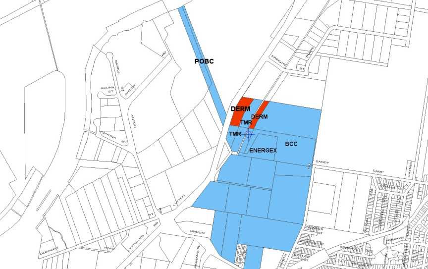
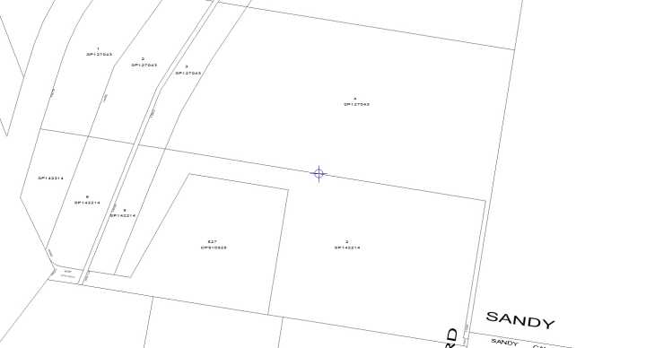
Suggest that you do your own research. Look at the RP plans attached for land on the eastern side of Lytton Road north of the drainage channel from Port West.
Point 5 response
I suggest that I cannot afford such a search for information but I am willing to meet you at your place of employment and assist you at the titles search counter as per attachments.
Point 6 response.
Cr Peter Cummings yet to respond
Paul Lucas MLA yet to respond
Dr Rick Morton yet to respond.
Port Connect
Robert Tutticci
Manager (Major Projects)) | Metropolitan Region / Brisbane Office
Assets & Operations Division | Department of Transport and Main Roads
Allan Uhlmann
Project Manager |
Major Infrastructure Projects | Department of Transport and Main Roads
Plus one other TMR engineer name unknown
Awaiting a response through Transport Minister
Brisbane City Council Noel Lawrence Engineer and Local Area Co-ordinator pH 3407 1480
DERM yourself
I have spoken to several other land owners in the area involved and keep some of them informed via email, web site and phone calls.
Please keep me informed as to your progress in this matter.
Barry Wilson
Chairperson
The Rivermouth Action Group Inc
P.O. Box 268
Morningside 4170 QLD
activist@rag.org.au
http://www.rag.org.au
pH 07 3399 6204
Mob 0416 564 244
27 August 2011